
Modern municipal administration is undergoing a fundamental transformation as regional authorities move away from reliance on manual visual inspections toward highly sophisticated, technology-driven housing safety frameworks. The initiative launched in Ulsan’s Jung-gu District exemplifies this shift by synthesizing high-resolution thermal imaging with comprehensive big data analytics to protect the community’s most vulnerable residents. By establishing a pioneering partnership with the Korea Land and Housing Corporation, the district has effectively created a digital safety net that identifies structural risks before they escalate into costly or dangerous failures. This methodology marks a departure from traditional reactive reporting systems, where residents must first identify a problem before any action is taken. Instead, the implementation of autonomous aerial surveillance and data-driven prioritization allows officials to allocate resources with surgical precision, ensuring that aging infrastructure remains habitable and energy-efficient for the long term.
Data-Driven Foundations for Urban Resilience
The success of this modern safety initiative relies on a complex six-stage data integration process that combines disparate information streams into a single actionable map for local government officials. By synthesizing social vulnerability statistics—such as the locations of single-person households and elderly residents—with cadastral mapping and flight regulation data from the Ministry of Land, Infrastructure and Transport, the district can pinpoint exact locations where intervention is most necessary. This analytical groundwork ensures that drone operations are not conducted randomly but are focused on specific energy vulnerability zones where structural deterioration is likely to be the most severe. This targeted approach is particularly critical when managing buildings that have been in service for more than thirty years, as these structures often possess hidden defects that traditional surveys might overlook. By layering geographical information with demographic data, the administration created a prioritization matrix that maximizes the impact of every public dollar spent on renovations.
Expanding beyond simple data collection, the collaboration between the local district and the Korea Land and Housing Corporation serves as a robust blueprint for inter-agency cooperation in the smart city era. This partnership facilitates a seamless transition from diagnostic testing to actual structural remediation by ensuring that empirical evidence is shared directly with the entities responsible for maintenance. Historically, bureaucratic silos often delayed necessary repairs because the data collected by one department was not easily accessible or formatted for use by the construction teams. However, this current model utilizes a unified spatial information system that streamlines communication and accelerates the deployment of repair crews to high-risk areas. Furthermore, by formalizing these workflows in 2026, the district is establishing a repeatable standard that can be scaled across various types of public and private housing. This systematic approach eliminates the guesswork traditionally associated with urban renewal, providing a transparent and efficient path toward improving the overall quality of life for the entire population.
Thermal Diagnostics and National Safety Standards
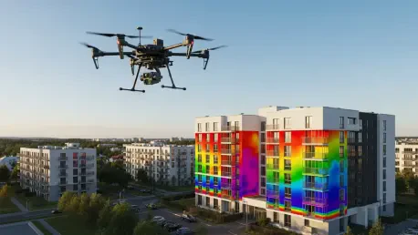
The technical execution of this program utilizes drones equipped with high-precision thermal sensors that are capable of detecting minute temperature variations across a building’s exterior surface. These advanced sensors identify critical structural flaws such as thermal bridging, where indoor heat escapes through the walls, as well as cracks in the masonry and gaps in rooftop insulation that are invisible to the naked eye. During diagnostic flights conducted throughout the spring months, the equipment provided a level of detail that traditional handheld thermal cameras could never achieve, especially when inspecting high-rise structures or hard-to-reach roofing sections. The resulting high-resolution imagery allows engineers to visualize exactly where airtightness has been compromised, enabling them to recommend specific materials and techniques for improving the building’s thermal envelope. By addressing these issues proactively, the district not only enhances the safety and comfort of the residents but also significantly reduces the energy required to heat and cool these aging structures, leading to a measurable decrease in the carbon footprint of the urban landscape.
As the findings from these drone inspections were uploaded to the National Spatial Information Integration Platform, also known as K-Geo, the program transitioned from a local initiative to a national benchmark for housing welfare. Integrating this data into a centralized platform allowed policy makers to monitor the condition of the housing stock in real time and provided a scientific basis for future urban planning decisions. This move towards data transparency and accessibility ensured that the lessons learned in Jung-gu could be applied to other regions facing similar challenges with aging infrastructure. The implementation of this “standard model” was specifically designed to eliminate energy blind spots and ensure that low-income residents were no longer disproportionately burdened by high utility costs resulting from poor insulation. By looking at the period from 2026 to 2028, the government sought to expand these aerial diagnostics to a broader range of rental units, ultimately fostering a more equitable and secure living environment. This proactive strategy successfully shifted the focus of public administration from crisis management to long-term structural health.